It's been raining in Ca for a while now. That's Ca rain, not real rain. But never the less it put a damper on riding. So yesterday (the 21 Feb) started a three day window of good weather.....though a little brisk at mid 50s at sea level. So I figured to make a break for the hills.
I'd heard about this Mildred falls and how a rock climber had died on the end of a 200 ft rope last week. Ordinarily a falls named Mildred is a water feature found in a rich man's back yard. I'd be much more impressed with Devils leap Falls or Grizzle Bear Falls.....but today I decide to go see the falls that killed the rock climber. It must be worth seeing if a 200 ft rope won't get you to the bottom of it.
Here's a teaser. It's a 6X zoom of Mildred
So to find the place I went to an online source for detail maps for natl forests. You can bring up a map file and zoom in and get a 'PRINT SCREEN' copy and then print it out to take along. Here's the site....most of their maps are Rockies and to the west.....a good resourse
[url]http://www.papermapsonline.com/home/SouthernCalifornia/ClevelandNationalForest.aspx[/url]
I gear up, such as it is, and am on the road by noon. The big Sabre roars to life as I fondle it's switches, and it responds eagerly as I let the reins out. In truth, I sat there and enjoy the wind in my face and the freedom of a jont on mtn twisties. I'll be going up to nearly 4000 ft and wonder at my decision to forgo my electrics.
It's about 70 miles out to the falls. I oscillate between the Ramona or Julian approach, and at the last minute decide on the Julian route. That's a longer ride but a shorter walk, I thought. I climb for the better part of an hour before I start picking up snow on the road at about 3300ft some 16 miles east of Ramona. I wonder if the road will even be open as I continue to climb. I made the turn onto Pine hills Rd. The snow got deeper as I climbed.
There's a foot of snow on the edges of the road at around 3800 ft, but I cleaned the summit there and start descending toward the falls. Once on Eagle Peak Rd it turned to dirt, and just a bit slimy in places. I'm very careful, but the Sabre is eating up the new environment like an F18 eats Afghan ass. :)
I don't really know where I am relative to my map, but the road is following a stream and does the same on the map. That's good.
 |
| From Mildred Falls |
A closer view...same crick
 |
| From Mildred Falls |
I soon see that I am in the area of Mildred Falls but that it is at least a 1/2 mile over some tough terain to my right. I chose to skip that and continued on to the Cedar Creek Falls, and I'd catch Mildred on the way back.
A mile further, and after 10 miles of dirt, I find the trail head to Cedar Creek falls. I can see that it will be a good hike, but don't know how far it is. There are 6 to 8 cars parked there, but on one to ask about the falls, so I start down the 5% grade. I see on Google Earth this morning that the drop to Cedar Falls is just over a 1000 ft. Even without knowing that, I figure it will be a struggle to get back up the trail.
Trail head to Cedar Creek Falls
 |
| From Mildred Falls |
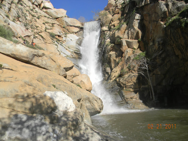
I note that looking back along the rode that I came in on I can see the spectacular Mildred Falls about a mile away. It's quite a scene even at that distance as the water cascades off a 400 ft cliff in the distance. I'm in awe of the scene, and wonder how I could live here nearly 60 years and not know about this place.
Mildred falls from the Parking area
 |
| From Mildred Falls |
 |
| From Mildred Falls |
The start of the hike to Ceder Creek Falls about 2 miles away. I'm guessing a 5% grade the whole way to the bottom of that canyon on the right.
 |
| From Mildred Falls |
When you're fresh, a down hill trail doesn't seem like a big deal as I scamper toward the unknown bottom. A mile later I meet a pair coming up the trail. The 30 year old gal is a 200+ pounder, and she is puffing and blowing big time. I took note of that, but continued on. They said it was at least another mile if not more.
My hats off to this gal for making the trip
 |
| From Mildred Falls |
That dam like thing just above the middle of the picture is my goal. Ceder creek comes out of that canyon coming from the left.
 |
| From Mildred Falls |
An hour and a half later I was at the falls Which required going up Cedar Creek a 1/4 mile.
 |
| From Mildred Falls |
.......but then the fall came into sight. For a Socal boy where free running water is a rare thing it was a hell of a waterfall at least 200 ft tall with a summer time pool at the bottom. The water temps today were no doubt sub 40s, but in the summer 95 degree days were the norm. That pool would be heaven at that time of year.
 |
| From Mildred Falls |
 |
| From Mildred Falls |
What a wonderful reward for the hike to the bottom. There were 15 people doing their thing around the pool and cliffs/boulders at the bottom.
 |
| From Mildred Falls |
I was there....
 |
| From Mildred Falls |
Vid of Cedar Falls....
Young man with no fear of high places
 |
| From Mildred Falls |
I'd arrived at the pool at 2:30 Pm. I'd seen enough by 3pm and started the trek back to the bike. It wasn't long and I could see this walking uphill thing was going to be epic for me. I started counting my paces. I set a goal of 200 left ft paces before I could rest. I figure that is 800 ft.
The sun is setting as I climb out...note little tree on top left, and Mildred falls on far right.
 |
| From Mildred Falls |
Little tree at a bunch of zoom wish I'd had a tripod.
 |
| From Mildred Falls |
Son of a bitch, that's tough. I'd done 4 of those sets before I quit setting down between sets, and began laying down. 3 minute breaks became 5 minute and longer breaks.
My pace was 'drag ass'. The kids just walked on by me. I couldn't even hear them puff. I tried to remember if I ever looked like that. Ha.
Though my pace remained 'drag ass'. I finally slowed enough that I didn't seem get any tireder. Don't get me wrong I still needed my breaks. Maybe the pain that was creeping into my left hip was taking my mind off the total fatigue pain.
I played with the camera some to take my mind off walking during my breaks. I borrow a camera from A girl in our condos who appreciated that I needed a 15X optical Zoom Nikon to get the distance shots. The distraction was nice.
Resting on the hike out. That a long ways down there. Just a little over a 1000 ft according to Google Earth.
 |
| From Mildred Falls |
A welcome first glimpse of the parking area. My tongue was hanging out. I had seen about 30 folks on this hike today.
 |
| From Mildred Falls |
Anyway I got back to the bike at shortly after 5pm. A gasoline engine never looked so good. I gathered my strength for another 15 minutes before suiting up for the ride home. I'd sweat a bit so that my t-shirt was damp. That didn't help any as I went back thru the snow field.
Looking west I could see glimpse of a dramatic red sunset, but it was behind mtns, and when I finally broke out with a good view to the west, the fleeting beauty was hardly more than a suggestion of it's former self. Damn, I lamented into my helmet.
I followed traffic down the mountain. I didn't have the energy to be aggressive. It felt good to get back to sea level temps. It was dark before I got home. The Sabre itself well for the round trip of 140 miles. I rode in on a blinking reserve fuel light. I decided fueling up could wait for another day.
Thanks for reading.